
I have previously blogged about Mineral King, discussing my first visit there in 2005 with Bob Gurr, the way you can see it through aerial photography, and the 2009 designation of the valley as wilderness. I recently returned from Mineral King from my seventh visit, but this one was special--my first winter visit.
To refresh your memory on Mineral King: long a part of Sequoia National Forest, the area saw repeated interest as a potential ski resort. Fifty years ago today the United States Forest Service issued a development prospectus and later that year Walt Disney Productions emerged as the winning bidder. Disney bought private land in the valley and the company spent three years creating a master plan for the year-round resort. The Forest Service accepted this plan in January 1969.

Many people believe that the Sierra Club is solely to blame (or credit) for the ski resort not happening. While it is true that the Sierra Club's lawsuit in June 1969 (against the Secretary of Agriculture and the Secretary of the Interior, not Walt Disney Productions) did delay the project, a primary reason the Disney ski resort (or any ski area) never came to Mineral King is the difficulty of getting up there in the winter. As I write in my masters thesis, the barely improved nineteenth-century wagon road did not afford year-round access. Putting a resort in possibly the premiere ski area in the world (a frequent turn-of-phrase in the development controversy) couldn't overcome the cost of modifying the road, or introducing a new transportation system.
Given my immense love of snow, it's only natural that I would want to be up in Mineral King in the winter. There are some privately owned cabins in the valley, which I assumed were inaccessible because of the Mineral King Road's closure from November 1 to Memorial Day. I knew people had gone up there in the winter, but I figured it involved miles and miles of cross-country skiing or snowshoeing, and then tent camping in the snow.
My experience, in comparison, was positively resort-like. In September I befriended Laile Di Silvestro, whose great-grandfather Arthur Crowley had patented land in the valley. This land later became a resort operated by Ray and Gem Buckman. The Crowley Cabin (built 1929) still sits on this land. One of the more interesting things (to me) is that it is actually on Disney property. Well before the prospectus was announced, Disney was interested in Mineral King and had surreptitiously purchased acres of private inholdings in and around the valley. The five-acre resort was prime property that could potentially put a stranglehold on any other developer's plans. Disney still owns this property, and much of it is the main parking area for valley hikes. As a result of my friendship with Laile, I was able to spend four nights in the high Sierra, on Disney property, surrounded by snow, and we had a national park to ourselves--all completely free. When's the last time you spent a free night on Disney land?
While on the Disney analogy, I must also mention that Laile seemed to me a premiere "Adventures by Disney" guide. An expert not only in the natural and human history of Mineral King, and in the nuances of this aged cabin, and in general hiking expertise and winter survival, Laile also anticipated everything we would need to enjoy our visit to the valley. And again, no surcharge for the service.

ABD Guide Laile
We drove up the road as far as we could, which turned out to be about 22 miles up, leaving another three to walk in. Faculty Flat (named for the many academics who owned summer homes in the area long ago) tends to have some of the deepest snow through the winter because of the tree cover. We came to this steep, snow-covered slope and knew it was time to give up on the automobile.

This is not an all-year highway
Getting the sleds up to the cabin was an adventure. Other cars had made it a bit further up the road, so we had some tire ruts to deal with. The sleds had a mind of their own, and we spent a lot of time righting them. At least on the way up we had greater control over their speed. Near the end of our three-mile trek, once we got to the sunny valley, we encountered a bare spot on the ground near the bridge crossing the East Fork of the Kaweah River. These bare spots were more numerous and troublesome on our way out, after four more days of 50-degree temperatures had melted a significant amount of snow.

The Mineral King Road with iconic Sawtooth Peak in the background
As excited as I was to finally be in the Mineral King valley in winter, it was even more incredible to stay in what I consider the premiere cabin in the whole area. It even has its own webcam attached! The cabin is old, creaky, and drafty (read: literally freezing at night), but it has so much character and history. Propane for the lighting and cooking helped to keep the wilderness at bay, as did the stove we kept feeding firewood to. I mentioned the daytime temperatures being in the low 50s during my visit. Every morning, we so welcomed the sun hitting the cabin at 9:30. It instantly warmed, well, everything. Because of the high surrounding mountains and the low sun angle, however, the sun "set" at the cabin around 2:30 p.m. Our first day this meant we were off the porch and warming up inside.

Crowley Cabin, 1929

Morning view from the cabin's porch
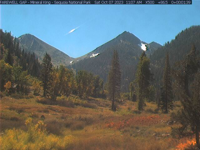
I mentioned the webcam. Here's today's view from the cabin.
There are actually four webcams in the Mineral King area, which we intended to signal from. The furthest down is at the private resort of Silver City. There we constructed a happy face out of some pine cones and pine needles.

We didn't make it to the Faculty Flat cam. In the Mineral King valley itself, there is the cabin camera (pointed toward Farewell Gap) and a camera on a National Park Service structure, pointing to Timber Gap. We'll get to the Timber Gap camera later. For the cabin camera, we came up with some ideas, but the first morning it was past 9 a.m. (the camera usually goes off between 9:20 and 9:30) and we had to do something, so Laile ran out and planted the American flag.

The next morning we took out two chairs, to plant ourselves in the view and have our hot beverages. The third morning we got ambitious and brought out a picnic table, made more difficult by the slushiness of the snow and how we broke through on each step while carrying the weight of the table. On the fourth morning, we felt we had done enough.
You might be wondering why I am not sharing all of these wonderful webcam photos that must have resulted from these efforts. As it turned out, we didn't know the camera's field of vision as well as we thought we did, and so for each of these activities we were out of the field of view. This is just as well, since it felt weird knowing we could be photographed at any moment.
Anyway, while we spent a considerable amount of time inside, we also took advantage of the placid winter weather to undertake a hike each day. The first two days we did five-mile roundtrips, with moderate elevation gain. The last day we did a more gentle exploration of the valley floor. You've already seen the many magnificent peaks surrounding the valley. The corollary is that when you go on a hike, there's no place to go but up, and everywhere you go offers a new perspective.
On our first full day in the valley, we went up to White Chief. The National Park Service describes it as "a steep but scenic hike up the west side of the Mineral King Valley." Steep it was. This marked my first time snowshoeing, but I picked it up pretty easily and enjoyed this new way to experience snow.

We arrived at the White Chief Bowl mid-afternoon, just as the sun was setting behind the mountains:

Our second day, to get some amazing aerial-like photos of the valley, we decided to head up to Timber Gap. The south-facing slopes had lost most of their snow, the exception being that the trail had many off-and-on snow patches (see photo of Laile above). Because I love the view toward Farewell Gap, I consider the Timber Gap trail one of the very best. The first part is rather steep (and in full sun), but offers ever-more-magnificent views with every step up. The trip required snowshoes only as we got under tree cover near Timber Gap. Laile led us out to a little west and above Timber Gap, near her favorite lunch spot. Sitting on the bare rocks, we were treated to a view that included not only the whole of the Mineral King valley, but also the Coast Ranges way out toward the Pacific Ocean.

The striking photo on the cover of Walt Disney Productions' Master Plan submittal in 1969, while taking from the air, was very similar to what we experienced as we had our late lunch.


Can you spot the cabin on the valley floor?
On the last day, I didn't have the energy for an 11-mile round trip to Farewell Gap and suggested that we instead hike toward the gap, but not take the trail to the top. This enabled us to tackle our signaling idea for the webcam pointed toward Timber Gap. We decided to stamp out a horse in the snow. Laile provided the artistic direction. The horse had a little bit of a paunch, but it ended up not mattering; the webcam only captured the upper part of the head.


The trip exceeded my highest expectations. (I had already grudgingly accepted that there was only a vanishing chance of falling snow.) I definitely look forward to future trips to Mineral King, including in the winter. Maybe I shouldn't even consider myself as visiting in winter until I've snowshoed nine miles uphill in a blizzard to reach the safety of the cabin (hopefully next winter!).
If you're interested in the thirteen-year development controversy, please consider following my Twitter account @SkiMineralKing. Until 2028, I'll be live-tweeting the 50th anniversary of the surrounding events. After 2028, you'll have to find other sources of entertainment.
